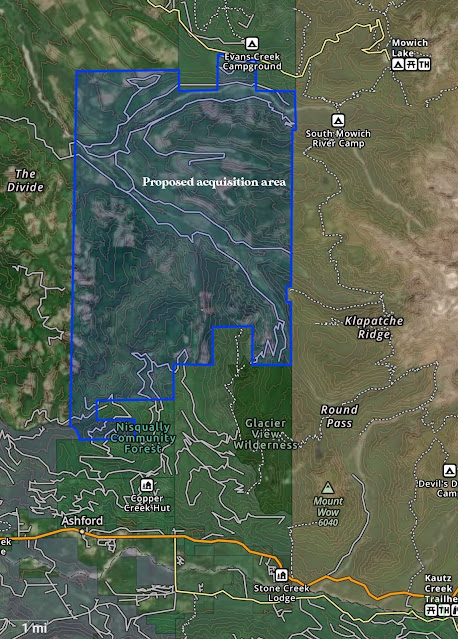
When the Fairfax Bridge over the Carbon River was closed, it cut off easy access to the Northwest corner of Mt. Rainier National Park, and it will be many years before construction might even begin on a replacement. There is a very real possibility that it will not be replaced at all, and while there are advantages to making that backcountry a remote and little-visited haven for wildlife, it does mean that more people will be crowded onto the finite number of trails elsewhere in the region. However, there is a solution to this problem which if swiftly acted upon could restore access to Mowich Lake and the Carbon River within just the next few years. It might surprise you to learn that the Mowich Lake Road isn’t the only route accessing this backcountry area, and that not all of Mt. Rainier lies within Mt. Rainier National Park. The western feet of the mountain protrude from the border of the park and onto private land, with clearcuts scarred into the slopes of Mt. Rainier itself. A network of logging roads extends from the Ashford area, all the way to the Mowich Lake Road, crossing both the Puyallup and Mowich rivers on bridges. All we need to do is acquire the commercial timberland adjoining the Western side of Mt Rainier National Park, and we could quickly reopen a public access route to Mowich Lake.
Now the first thing you might be wondering is “won’t this be too expensive”? In answer, you need to realize that the estimated cost of replacing the Fairfax Bridge is $42 Million, and that would likely cover most of the cost of acquiring what works out to be roughly 29,000 acres of remote commercial timberland which has mostly all been recently cut. Spending that money on land conservation would net us far more than just road access to Mowich Lake, it would begin the process of healing a landscape degraded by a century of industrial logging. In so doing, it would create the additional visitor capacity which is so desperately lacking in our existing public lands.
These lands, while damaged, have great potential for restoration, as well as new hiking trails and tent campgrounds. For restoration, all that would essentially be required is the thinning of low diversity overly dense timber plantations. Some of the more recent clearcuts could be restored as meadows and prairies. The many extraneous old logging roads would be decommissioned, though that would not be a priority.
For hiking, I envision a network of trails following the Mowich and Puyallup Rivers, along with various creeks, connecting to the old Westside Road and Wonderland trail within the park, and climbing to high ridges and locations such as Puyallup Ridge Lookout. Trails would be very much in the old style of bootpaths - fun, relatively easy to build, and low maintenance. Similarly, the road would remain gravel, with perhaps moderate improvements over time, allowing for future funding. This would be a primitive area, intended to be cheap to maintain and low impact, but offering an expansive range of opportunities for tent camping and hiking. It might not be the most attractive portion of Mt. Rainier, requiring many years to recover, but it would offer a much needed way to get away from the crowds.
Ultimately, such a land acquisition is something which needs to be pursued regardless of the fate of the Fairfax Bridge. It is painful to see such a once-beautiful landscape so badly abused by timber corporations, and it is abhorrent indeed that chainsaws buzz on the very slopes of Mt. Rainier, mere steps away from the Wonderland Trail at points. It’s clear that Mt. Rainier National Park was not made large enough to contain the diverse ecosystems and scenic landscapes which it is so renowned for, nor is it expansive enough to cater to the multitudes which throng to this ice-clad monarch and its robe of emerald green. This is our opportunity to begin correcting the errors of ages past, and to restore public access to a beloved region of the park.


